

Wind and sky
My favourite Wellington walk (6 minute read)

I’m not in the mountains, but I’m as close as I can get without leaving Wellington. It’s one of those rare days with only a light breeze, and the undulating grass shines like gold as it catches the sun. Wind turbines rotate lazily on the ridgelines and the skies are so clear across Cook Strait that I can identify Takapourewa/ Stephens Island on the far side of the Marlborough Sounds. If I turn around, I see the whole of Wellington Harbour, with the Remutaka Ranges beyond.

Wellington’s Skyline Walkway is, to me, one of the city’s most magical places. It stretches from Johnsonville in the north to the back of Karori, and on a map it appears that it’s never more than a kilometre from the city’s western suburbs. On the ground, though, it feels remote. Apart from on the high point at the top of Tarikākā1, I’ve never encountered more than a couple of other people walking there. There’s just a track along the ridge, surrounded by grass and wind-stunted shrubs, with views so expansive that I feel my soul soaring.
I discovered this track years ago, when I was walking my dog, Donna, although in those days she wasn’t my dog. Her previous owner struggled to give her the exercise and activity she needed, so I used to take her out three times a week. One summer evening, we walked up Tarikākā and I looked towards the hazy golden light in the south-west. According to the map, we could walk along the ridge for a while, cut down into the back of Khandallah and walk around the streets to our starting point. There was enough daylight and Donna never turns down a walk. So, off we went.
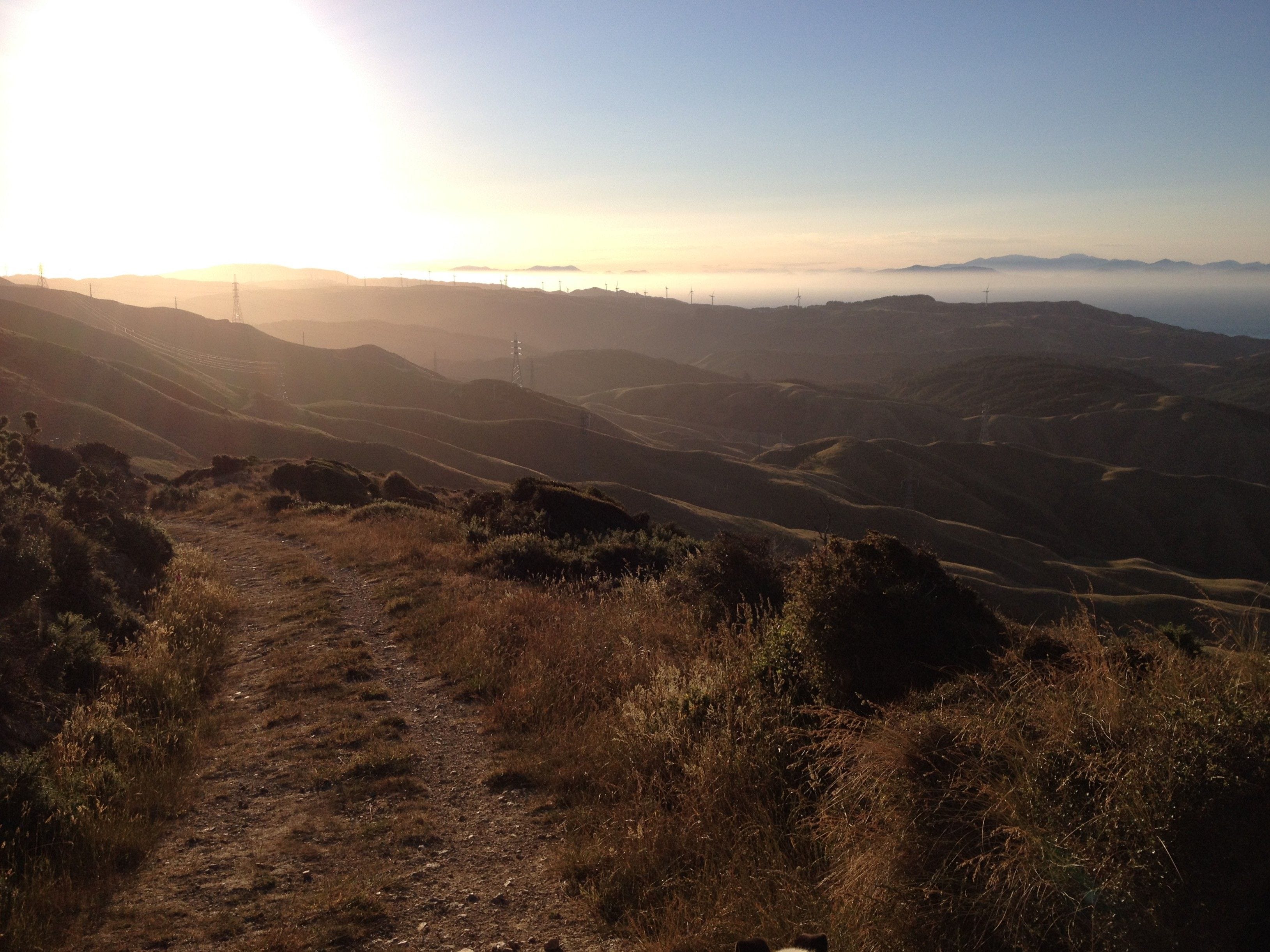
According to the recollections of local residents, recorded by the Onslow Historical Society, there were once tōtara trees growing on the Tarikākā summit, so it must have originally been forested. It’s hard to imagine now. The area was logged, burned and turned into farmland more than a hundred years ago. To the west of the Skyline Walkway, most of the land is still farmed. The rippled hills are pale, every gully exposed, with nothing more than the shallow roots of pasture grasses holding the soil in place. Even as I admire the beauty of the deeply-channelled terrain, know that it’s damaged land.

Every time it rains, more of the soil is washed into the streams, turning them yellow brown. Eventually, the sediment finds its way into the harbour, carrying away the land’s fertility and disrupting marine life in the harbour. Some of that grassland is reverting to forest on the Skyline Walkway, but it’s a slow process. It’s a harsh place for plants to grow. The soil is no longer replenished by thousands of seabirds. There’s no shortage of rainfall, but the winds are brutal.
On top of Tarikākā, there’s a television tower, and on top of that, there’s a wind recorder. During a storm in May of this year, it stopped working after it was damaged by wind speeds of over 150 kilometres per hour (93 MPH for my American readers). But it’s the average which is more telling – 44 kilometres per hour (or 27 MPH). On the Beaufort scale, this is a strong breeze, enough to set large tree branches in motion and make the use of umbrellas near to impossible. It’s only one category below near gale, when walking becomes difficult.
Of course, this doesn’t mean it’s like that every day on the Skyline Walkway. I’ve mostly enjoyed glorious weather, because I don’t try going up there when the weather is bad. The worst I’ve encountered was the day Donna and I walked up on a damp misty day and couldn’t see a thing from the summit.
The wind, quite literally, shapes the plants which grow near the skyline. An eastward lean is characteristic of Wellington vegetation, due to the prevailing westerly winds. The influence of the wind can also be seen in the dense, close canopy the plants form, whether it’s native species or, more commonly, the gorse and Darwin’s barberry which now dominate. Darwin’s barberry is native to southern Chile and Argentina, and thrives in Wellington. Like gorse, it’s viciously spiny, but unlike gorse it’s tolerant of shade. It’s likely to remain an unpleasant part of Skyline Walkway’s flora in the years to come.

Not that some of the native species which grow there are any more pleasant to encounter than gorse and Darwin’s barberry. As much as I love the giant tree nettle, it’s not the kind of plant you want to bump into. I was also excited to spot speargrass in full flower near the central part of the Skyline Walkway last summer. I love speargrass, a conspicuous and distinctive plant, with its long, narrow leaves tipped with sharp points. But I’ve had more than one painful encounter when I got too close to the leaves.
Many of the native shrubs on the Skyline Walkway are described as divaricating, which means they branch at wide angles and develop densely interlaced stems. The leaves are small, and often inside the mass of branches. It’s usually considered to be an adaptation against wind abrasion and frost, although there’s an alternative theory that it’s an adaptation to moa browsing. One day I’ll write more about this debate, as it’s intriguing and, in my view, not as simple as one or the other.

When it comes to small-leaved shrubs, my botany skills are lacking. I made an effort around 25 years ago and could identify a good number of them, but when I look at them now, I’m baffled. I’ll be leading a trip along part of the Skyline Walkway for the Botanical Society in late summer, so that I can get some expert help.
I’ll enjoy taking the Botanical Society, but we are only going to walk a short stretch of the walkway. Almost all of my trips there have been just short segments, because I have to get back to my car, and walking for hours through the streets is much less fun. It’s possible to catch the bus back, but not if you do the walk with a dog. The longest stretch I’ve done is from Tarikākā to Crofton Downs, which is about half way. Donna and I did the walk with a friend who didn’t mind having Donna in her car.
One day, I want to walk the full length of the track. I hope I’ll be able to take Donna, who is becoming less agile as she ages but is as energetic as ever. She loves it up there, and it’s wonderful to see her in the environment she was bred for. She was not meant for life as a city pet.
This was never clearer than when she first encountered sheep on the track. Even before we could see them, I could see her eager anticipation. The moment she saw the sheep, which were just on the other side of a small rise, she knew exactly what to do. She stood stock-still and stared at them. Eventually I got her attention, with treats again, and we walked on. We haven’t been close to sheep on most of our other walks, but I’ve always given her treats as soon as we see them. On one of our more recent walks, we came quite close to a few sheep and she ignored them completely, looking at me for treats instead. The sheep, however, took one look at her and were off.


Most people in Wellington call this hill Mt Kaukau, but I’ve researched this name and it’s meaningless, simply a mispronunciation of kākā, which was a shortened from Tarikākā. In the 1920s, the Chief Draftsman with New Zealand Lands and Survey tried to get the map corrected back to Tarikākā, but he was over-ruled.
I didn’t know that about the name! Thanks for explaining. I live at the base of Ahumairangi and am itching now to go for a walk…
Beautiful photos. My dad called this landscape “the leonine land”. Glad to know there is ongaonga up there, though it may be too windy for kahukowhai! And I’m thinking it may one day be kiwi country again.